
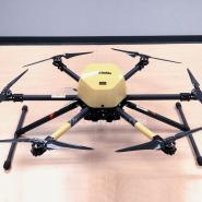
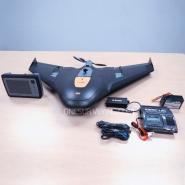
Used Trimble ZX5 UAV Complete System
Used Trimble ZX5 UAV Complete System for sale, still like new, low hours flights used, it is in excellent ready to flight to survey condition
Used Trimble ZX5 UAV for sale, Complete Trimble ZX5 System for Land Survey
Very lightly used, still like new, low hours flights used by professional surveyor land surveyors. Been shop tested, serviced and calibrated by Trimble authorized to insure reliability, accuracy with Trimble working standards. In excellent ready to working to flight to survey and works flawlessly condition
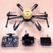
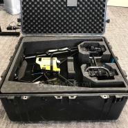
Used Trimble ZX5 UAV System sale includes:
- Trimble ZX5-SYS-004
- Tablet with Aerial Imaging application
- Olympus PEN E-PL7 camera with LUMIX 14mm pancake prime lens, micro SD card, charger, cabling
- Remote Control
- Chargers
- ZX5 Batteries
- Case
Trimble ZX5 Overview
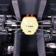
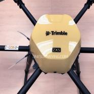
The Trimble ZX5 is another accurate, reliable tool in Trimble’s family of UAS solutions. Fast to setup and easy to operate, the Trimble ZX5 allows you to quickly collect data in the field so you can generate the dynamic deliverables required for today’s jobs. It requires no launcher, is easy to deploy and includes everything you need to capture high quality georeferenced photos for applications such as aerial mapping and inspections.
- Vertical takeoff and landing capability allows users to work in tight places and obstructed environments where fixed wing solutions are less suitable.
- The system can be equipped to capture live video imagery for inspection applications such as civil infrastructure, utilities, and oil and gas pipelines.
- Simple field-to-office workflows ensure reliable results
- Easily integrate with other Trimble technology
- Image Processing
Import your data into Trimble Business Center Photogrammetry Module office software to create detailed orthophotos, digital elevation models, point clouds, volume calculation, 3D models and more without requiring specialized photogrammetry knowledge or experience. Or utilize the state-of-the-art Trimble Inpho UASMaster module for advanced photogrammetric processing.
Features
- Outstanding flight stability and performance even in strong winds
- Includes a 16 MP camera system and flight planning software
- Image resolution down to 1 mm
- Light, compact,foldable carbon design
- Up to 20 minute mission duration and 2 km range
- Easy data processing in Trimble Business Center Photogrammetry Module or Trimble UASMaster
Specifications:
Hardware
- Type: Rotary Wing
- Maximum takeoff mass: 5 kg (11lb)
- Payload capability: 2.3 kg (5.1lb)
- Dimensions: 85 x 49 cm; (33.5 x 19.3)
- Material: Carbon frame structure
- Propulsion: Electric pusher propeller; 6 brushless motor
- Battery: 2x 6600 mAh 14.8 V
- Camera: 16 MP with interchangeable 14mm lens
Software
- Project management: √
- Mission planning: multiple flight
- Automated pre-flight checks: √
- Automatic take off, flight and landing: √
- Autonomous camera triggering: √
- Automated fail-safe routines: √
- User controlled fail-safe commands: √
Operation
- Endurance: 20 min
- Maximum ceiling2: 3000 m (9,843 ft) AMSL
- Pre-flight setup time: 5 min
- Take off type: Vertical
- Landing type: Vertical
- Weather limit: Stable in winds up to 36 km/h (22 mph)
- Communication & control frequency: 2.4 GHz
- Communication & control range: up to 2 km (1.2 miles)
- Video Frequency: 5.0 GHz
- Live Video Stream Resolution: 480i
- Recordable Video Resolution: 1080p30
Acquisition Perfomance
- Resolution (GSD): 1.0 mm to 19.5 cm (0.04 -7.7 in), depending on height above ground level (AGL) and less
- Flight AGL range: 5 - 750 m (16.5 - 2,460 ft)